
Minor earthquake hits Cumbria
Whitehaevn News, 08:30, Wednesday, 22 December 2010
An earthquake shook buildings across Cumbria last night prompting floods of calls to police from concerned residents.
Related: Cumbria earthquake page on British Geological survey Related: Cumbria earthquake page on US Geological Survey
The quake - classed as 'minor' - was felt across Cumbria and in Lancashire, south-west Scotland, parts of Yorkshire, Northumberland and the Isle of Man.
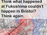
The Brtish Geological Survey said the tremor - which happened just before 11pm - measured 3.5 on the Richter Scale and was centred on the Coniston area.
It occurred about nine miles underground.
There are no reports of any injuries or damage to buildings.
Mr Peter Kelly, owner of the Yewdale Hotel in Coniston, said: "It was quite noiceable. We were just closing up the bar with a few residents in and we just felt like a bang and then a rumbling but we couldn't decide what it was".
Hotelier Alan Robertson, who was in his 30-bed hotel in Eskdale, added: "The entire building shook. I ran out of the front door to be confronted by my guests running out of their part of the house. We couldn't believe it".
One man, who lives in High Harrington, near Workington, said: "It lasted a few seconds and sounded like a dull rumble. My wife felt the ground shake as she was sat on the settee in the living room.
"Our daughter came running down stairs saying her bed had moved and a wardrobe door had opened."
Christopher John Gabbott, writing on Facebook, said: "We just had an earthquake in Windermere. I was typing an email and there was one hell of a noise and a rumbling, thought a building had fallen down outside somewhere."
Nicola O'Hare wrote: "[I] thought the house was going to fall down!!"
And Neil Wilkinson said: "Bed shaking earthquake in Cumbria a few minutes ago, glad it didnt last long, the whole house shook."
Dale Grant, of the US Geological Society, which also records global seismic activity, said quakes were not uncommon in the area.
He added: “We have had 'quakes dating back to 1976. This is a seismically active area.
“The largest that we have ever recorded is a 4.3 (magnitude tremor) on November 21, 2002."
Mr Grant said the 3.5 tremor, initially reported to be 3.6, “would have got people's attention”.
“But this is not the type of magnitude that would lead to extensive damage,” he added.
“It is something that will be roundly felt in the area but, quite fortunately, it's not any bigger than it is.”
Quakes between 3.0 and 3.9 on the Richter Scale - used to rate the amount of energy released - are classed as minor. They are often felt but rarely cause damage. There are an estimated 49,000 of these quakes across the world each year.
A quake measuring 3.7 was recorded in Ulverston last April. One of 4.4 struck Lancaster in 1835.
BGS Head of Seismology Dr Brian Baptie said: "We get an earthquake of this size somewhere in the UK roughly every 12-18 months.
"An earthquake of this size and depth might be felt 80-100km away. The quake has probably made windows and doors rattle and small objects may have been displaced".
It came around 24 hours after quakes of a similar magnitude were felt on the Norwegian Coast.
An earthquake shook buildings across Cumbria last night prompting floods of calls to police from concerned residents.
Have your say
I was on the sofa when i heard it, i thought it was a large lorry going past, my son came down the stairs and said everything vibrated in his bedroom, then texts started coming in from friends, saying it was a tremor. I thought it may have been caused by underground mines from the Cleator moor area.
Posted by Tracey on 22 December 2010 at 10:30i felt it i was downstairs on the sofa when our walls and floor began to shake in our living room it scared me i thought it was an earthuake but very minor our house shook to but not very loud from emily
Posted by Emily Howard on 22 December 2010 at 10:01a.pearson - who does your Dad think he is, do you not think that Cumbria has suffered enough recently?
Posted by Jackie on 22 December 2010 at 09:41I hope copeland and allerdale will now put to bed the idea of an underground depositary for nuclear waste once and for all, this is the sixth earthquake to happen in six years within a 40 mile area(US met data).time to face up to it the ground is not adequate, unless your those people who don't care "because you won't be here", in the future years.
Posted by James O on 22 December 2010 at 09:36My wardrobe started shaking like something off the exorcist last night around 11pm.
Posted by Laura on 22 December 2010 at 09:35We were in bed, I just put it down to my boyfriend passing wind
Posted by Stacy on 22 December 2010 at 09:02Was sitting on the floor and the earth moved for me!
Posted by Michelle on 22 December 2010 at 09:02never felt a thing flat out in bed only found out when wife told me when she came to bed
Posted by john on 22 December 2010 at 08:42Is there any implication for burying spent waste ?
Posted by Charlie Osborne on 22 December 2010 at 07:59...which shows just why we shouldn't be an area chosen to store nuclear waste underground!
Posted by Dave Evans on 22 December 2010 at 07:33Times & Star, 19th Feb 2009
Without a new high-level waste dump, the Government’s plan for a new atomic power station would be hard to achieve, but disposing of this highly dangerous materials in a heavily faulted area is not a good idea.
Geologically, this region is not safe and we have a duty to ensure that future generations are protected from any possible radioactive leakage.
Councillors should also take heed that a scientist has warned that recent studies have shown there is a link between atomic sites and incidents of cancer.
The dynamic processes affecting the geology of the earth’s crust continue, and the rocks of West Cumbria are unstable.
They are heavily faulted and folded and have been subjected to considerable earth movement in the past.
Beneath Cumbria, gravitational surveys have proved that there is a large granite pluton that is slowly continuing to rise, placing increasing stress on our surface rocks. Additional stress is caused by the North Sea basin gradually sinking.
Undoubtedly, in time, this will lead to further folding and faulting of the strata, with the strong possibility of earthquakes when there is a sudden release of pressure.
In Britain we average about 200 earth tremors each year, although our country is much safer than some other parts of the world.
A number of sizeable earthquakes have been recorded in recent times. In Cumbria, there have been several; Kirkby Stephen on August 9, 1970, measured 4.9 on the Richter scale, with another near Carlisle on Boxing Day 1979 and even more recently, on Boxing Day 2006, centred near Dumfries.
The most famous of all British earthquakes happened in 1580AD and was centred under the Straights of Dover. Much destruction was spread throughout the home counties and debris falling from St Paul’s Cathedral cost several lives.
It is clear that careful thought and planning must be given for the long-term storage of this extremely dangerous material and it needs to be placed at a considerable depth within stable rocks, but Cumbria is not the right place and there are other areas of Britain which would be preferable.
TONY RIGBY
Cumbria Geological Society
Cockermouth

Geological report of West Cumbria published as part of Managing Radioactive Waste Safely process (Press Release)
“We must progress implementation of geological disposal, the long-term sustainable solution for dealing with radioactive waste.”(Charles Hendry)
28 October 2010
Press Release 2010/114Government today welcomed delivery of an initial geological report for West Cumbria. The study looked at the Copeland and Allerdale areas, where a local Partnership is talking to Government about the siting process for a deep geological disposal facility for nuclear waste.The screening does not show where a facility would eventually be located, but is simply intended to avoid unnecessary work in areas which are clearly unsuitable based on high level geological exclusion criteria.Minister of State for Energy Charles Hendry said:
“We must progress implementation of geological disposal, the long-term sustainable solution for dealing with radioactive waste.“Today’s report, commissioned from the British Geological Survey, is a step forward. The geological disposal facility site selection process is based on voluntarism and partnership and these results do not present any reason why West Cumbria cannot continue to consider whether or not to participate in that process.”The exclusion criteria were derived by two independent expert groups, were high level and were primarily based around the risk of intrusion by future generations seeking to extract resources and the need to protect the quality of exploitable groundwater.The study was desk-based and used available geological information. If a community chooses to proceed further, increasingly detailed geological and other criteria assessment would have to be undertaken.The work is part of the Government’s Managing Radioactive Waste Safely programme and the invite for communities across the Country to find out more about the siting process remains open.
Notes for Editors:
- The ‘Initial Geological Unsuitability Screening of West Cumbria’ report commissioned by DECC and carried out by BGS is available from:http://mrws.decc.gov.uk/en/mrws/cms/disposal/site_selection/initial_screen/west_cumbria/west_cumbria.aspx[External link]
- The Managing Radioactive Waste Safely White Paper was published in 2008 and includes the geological exclusion criteria at annex B. The White Paper is available at: http://mrws.decc.gov.uk/[External link]
- The geological exclusion criteria were derived by two independent expert groups, each comprising of scientists with high calibre experience. Their draft criteria were part of Government’s 2007 Managing Radioactive Waste Safely (MRWS) consultation and the Chairs of both expert groups then reconsidered the criteria in light of the responses received before final publication in the MRWS White Paper. Information on the work of the independent expert groups is available at:
http://mrws.decc.gov.uk/en/mrws/cms/disposal/site_selection/initial_screen/initial_screen.aspx[External link]
Initial geological unsuitability screening of west Cumbria
On 28 October 2010 a report was published setting out the results of the high-level geological unsuitability screening for the Copeland and Allerdale areas of west Cumbria undertaken by the British Geological Survey (BGS). The geological screening was a desk-based study only, using currently available information and not involving new field investigations. It used basic high-level geological criteria, set out in the Managing Radioactive Waste Safely (MRWS) White Paper, to rule out areas that could not host the underground workings of a geological disposal facility for higher activity radioactive waste.
The study covered an area for which local authorities had expressed an interest in entering ‘no commitment’ discussions with Government about the siting process. Its purpose is to exclude from further consideration areas which would be clearly unsuitable to host the required underground workings and allow communities and Government to avoid unnecessary discussions in relation to such areas.
The study did not consider any non-geological factors and does not show where a facility would eventually be located. This is an early stage in the siting process and further, increasingly detailed, assessments applying more localised geological and other criteria will only be made IF a community decides to participate further.
A copy of the main report (with figures 3-14 as separate pdf files), the non technical summary and other information can be downloaded using the links below:Initial geological unsuitability screening of west Cumbria: main report Size: [2.13 MB] File Type: [.pdf]Initial geological unsuitability screening of west Cumbria: figures 3-8 and 10-14 Size: [2.26 MB] File Type: [.pdf]Initial geological unsuitability screening of west Cumbria: figure 9 Size: [1.66 MB] File Type: [.pdf]Initial geological unsuitability screening of west Cumbria: non technical summary Size: [1.14 MB] File Type: [.pdf]MRWS Factsheet 5 - Stage 2: Sub-surface unsuitability screening Size: [756 KB] File Type: [.pdf]FAQ: Sub-surface unsuitability screening Size: [138 KB] File Type: [.pdf]Page last modified: 27/10/2010 12:15:32
Managing Radioactive Waste Safely:Initial Geological Unsuitability Screeningof West Cumbria: Non Technical SummaryCommissioned Report CR/10/072CR/10/072 MRWS: Initial Geological Unsuitability Screening of West Cumbria1Managing Radioactive Waste Safely: InitialGeological Unsuitability Screening of West CumbriaNon Technical SummaryBackgroundIn 2001 the UK Government began the Managing Radioactive Waste Safely1(MRWS)programme with the aim of identifying a long-term solution for the UK’s higher activitywastes that:• achieved long-term protection of people and the environment• did this in an open and transparent way that inspired public confidence• was based on sound science, and• ensured the effective use of public monies.In 2003 the independent Committee on Radioactive Waste Management (CoRWM)2wasestablished to consider the available options and make recommendations to Government. InOctober 2006, the Government accepted CoRWM’s recommendations that geologicaldisposal, preceded by safe and secure interim storage, was the best available approach.Government also accepted that an approach based on voluntarism, and partnership with localcommunities, was the best way of siting a geological disposal facility (GDF).Geological disposal involves placing radioactive waste within engineered, multi-barrier facilitiesdeep inside a suitable rock formation where the facility and geology provide a barrier against theescape of radioactivity. Internationally it is recognised as the preferred approach - it is beingadopted in many countries including Canada, Finland, France and Sweden - and is supportedby a number of UK learned societies including the Royal Society, the Geological Society andthe Royal Society of Chemistry.Following further consultation, the White Paper ‘Managing Radioactive Waste Safely(MRWS): A Framework for Implementing Geological Disposal’ was published in 2008; itsets out a staged approach to siting a geological disposal facility. The process starts with localcommunities initially ‘expressing an interest’ in opening up discussions with Government. Ateach stage, the process allows all those involved to take stock before deciding whether or notto move to the next stage at a particular site. Up until late in the process, when undergroundoperations and construction are about to begin, the community has a Right of Withdrawal - ifit wished to withdraw then its involvement in the process would stop. Figure 1, below, showsthe main stages in the process.The Nuclear Decommissioning Agency (NDA) have since published an additional document‘Geological Disposal: Steps towards implementation’3 which provides further information onwhat will be required for the successful implementation of geological disposal.1 http://mrws.decc.gov.uk/2 www.corwm.org.uk
CR/10/072 MRWS: Initial Geological Unsuitability Screening of West Cumbria2Figure 1. Stages in the site selection process (after Defra et al., 2008); this report addressesStage 2.Initial screening out of unsuitable areasFollowing an expression of interest, the White Paper sets out the second stage, in which theBritish Geological Survey (BGS) undertakes a high level geological screening of the areausing basic geological exclusion criteria that can be applied using existing knowledge. Thisscreening is desk based, uses existing information and will not produce sites that coulddefinitely host a facility, but will rule out areas that definitely could not host a facility forobvious geological reasons. At further stages of the site selection process increasinglydetailed assessments would be made of any potential sites, applying more localisedgeological and other assessments. Areas which are ruled out in this initial sub-surfacescreening exercise might still be suitable locations for the surface facilities of a GDF.Geological exclusion criteriaThe geological exclusion criteria were derived during 2007 by two independent expertgroups, each comprising of scientists with high calibre experience, and established followingdiscussion and nominations from the Royal Society, the Geological Society and the RoyalAcademy of Engineering. One group (Criteria Proposals Group) proposed a suitable set ofscreening criteria and the other (Criteria Review Panel) then peer reviewed them to ensurethat they were workable. The results were consulted on by Government in 2007 and theChairs of both groups then reconsidered the criteria in light of the responses received beforethe final publication of the MRWS White Paper in 2008.It is important to note that the exclusion criteria were derived to provide an initial ‘first cut’,solely to remove any obviously unsuitable geology from further consideration. The criteriacould not be area specific and had to be suitable for application to any area of the country that‘expressed an interest’. The criteria need to recognise the early stage of the site selectionprocess in which they are applied and, as such, have to be applicable across potentially largegeographical areas using existing information only. They are strictly geology based and, atthis stage, they cannot consider detailed site-specific information such as local small scalegeological features, the environmental impact of a facility, potential transport routes,population density, etc. Detailed examination and assessment of criteria based on theseaspects will necessarily come later in the process if, and when, a community decides it wantsto be involved further in the site selection process and actually begins to consider specificsites.The final exclusion criteria agreed by the expert Chairs of the two groups are summarised4 inTable 1.Table 1. Summary of initial sub-surface screening criteriaThe final exclusion criteria are high level and largely based around two key issues - the needto exclude areas in order to reduce the risk of intrusion into a facility by future generationsseeking to investigate and extract resources, and the need to protect the quality of exploitablegroundwater.The criteria groups also considered the case for and against a number of other geologicalexclusion criteria such as risk of earthquakes, geological faults, specific complex geologicalenvironments, erosion, etc. Following detailed consideration, the two expert groupsconcluded that these characteristics, although absolutely crucial in the investigation and4 For the authoritative explanation of the exclusion criteria the CPG/CRP full advice and subsequent review documentshould be read. Available at http://mrws.decc.gov.uk/en/mrws/cms/Disposal/Site_selection/Initial_screen/Initial_screen.aspx5 “Shallow”, in this context, means less than 500 metres below the surface. Therefore, “deep” and “at depth” mean more than500 metres below the surface.6 Rock mass consisting of carbonate rocks (e.g. limestone) characterised by dissolution through the action of slightly acidsurface and groundwaterTo be appliedas exclusioncriteria?Reasons/explanations and qualifying commentsNatural resourcesCoal Yes Intrusion risk to depth, only when resource at >100mdepthOil and gas Yes Intrusion risk to depth, for known oil and gas fieldsOil shales Yes Intrusion risk to depthMetal ores Some ores Intrusion risk only where mined at depths of >100mDisposal ofwastes/gas storageYes Only where already committed or approved at>100m depthGroundwaterAquifers Yes Where all or part of the geological disposal facilityhost rock is located within the aquiferShallow5permeableformationsYes Where all or part of the geological disposal facilityhost rock would be provided by permeable formationsthat might reasonably be exploited in the futureSpecific complexhydro-geologicalenvironmentsYes Deep karstic6 formations and known source rocks forthermal springs
CR/10/072 MRWS: Initial Geological Unsuitability Screening of West Cumbria4assessment for a geological disposal facility, can only be properly considered later in theprocess at a site-specific level when more in-depth investigations can take place on the detailsof a particular site.The initial geological unsuitability screening of west CumbriaSince Government’s call for communities to ‘express an interest’ in finding out more aboutthe geological disposal siting process in 2008, three local authorities (Allerdale BoroughCouncil, Copeland Borough Council and Cumbria County Council) have expressed aninterest for the areas of Allerdale and Copeland.The Councils have set up the West Cumbria Managing Radioactive Waste Safely (MRWS)Partnership7 to ensure that people living in the area are involved in making an informeddecision about whether or not to proceed with the facility siting process. The Partnershipincludes a wide range of local organisations and, following initial public engagement, it wascontent for the Department of Energy and Climate Change (DECC) to commission the BritishGeological Survey to undertake the application of the sub-surface unsuitability test describedabove.This work does not show where a facility might eventually be located. It is at an early stagein the site selection process and simply intends to avoid unnecessary work in areas which areclearly unsuitable for obvious geological reasons. A more rigorous assessment, based on acomprehensive range of criteria will only be undertaken if a ‘decision to participate’ infurther stages of site selection process is taken.The geological sub-surface screening report covers the known geology of Allerdale andCopeland and, at the request of DECC, an adjoining area 5 km offshore. The report considersareas that have clearly unsuitable geology for an underground geological disposal facility forradioactive waste, the depth of which is likely to be somewhere between 200 and 1000 metresbelow ground surface, but this will depend on the geology at the site in question.This initial screening out exercise and report is based on the analysis of existing records,reports, BGS ‘memoirs’ and maps, and relevant published scientific literature on the geologyof the Partnership area in relation to the recommended high level, sub-surface geologicalscreening (or ‘exclusion’) criteria (Table 1).The Partnership area has a varied geology including formerly worked mineral resources (e.g.coal and metal ores) and some exploitable groundwater resources. A general account of thegeology and hydrogeology of the Partnership area is illustrated with simplified geologicalmaps and cross-sections in order to provide a background for the non-geologist. The subsurfacescreening criteria have been systematically applied to the geology and hydrogeologyof the West Cumbria Partnership area and are discussed in detail. Figure 2 summarises theoutcome of the sub-surface screening exercise and shows the areas that are screened out(‘exclusion areas’) where one or more of the exclusion criteria apply to the whole rockvolume between 200 m and 1000 m depth.Natural resources exclusion criteria (Table 1) most relevant to the Partnership areacomprise: (a) coal and coal-bed methane (intrusion risk to depth), (b) oil and gas (intrusionrisk to depth), and (c) metalliferous ores (where mined at greater than 100 m depth).Areas known to be underlain by coal and hematite (iron) ore at greater than 100 m depth arescreened out. These areas (Figure 2) comprise parts of the Partnership area extending northwestfrom Egremont and Whitehaven to Wigton and the Solway coast, and a small area near
CR/10/072 MRWS: Initial Geological Unsuitability Screening of West Cumbria5Millom. The areas represent sub-surface rock volumes where there is a potential risk ofinadvertent intrusion into a geological repository by future generations seeking to investigateand extract resources. Other metalliferous ores have been historically worked in thePartnership area, but these lie at shallow depths, less than 100 m, and the areas are notexcluded.Exploration for oil and gas (‘conventional hydrocarbons’) has taken place in the north of thePartnership area, but no resources have been proved. Consequently, although a part of northAllerdale is currently licenced for oil and gas exploration, the area has not been screened outat this stage since it does not represent a known oil and gas field. Similarly, gas derived fromthick beds of organic-rich shales (known as ‘shale gas’) has not been proved in thePartnership area. Minor amounts of oil have been reported historically from coal-bearingrocks, which are excluded at depth (see above), but there are no known potentiallyexploitable oil shales resources in the Partnership area. There are no committed or approvedareas (rock volumes) for the disposal of waste/gas storage in the Partnership area.Groundwater exclusion criteria (Table 1) have been applied to exploitable groundwaterresources in aquifers (e.g. Sherwood Sandstone Group) and shallow permeable formations, aswell as specific complex hydrogeological environments.Some, but not all, of the rock volume in areas where aquifers and shallow permeableformations are present in the Partnership area are excluded. However, nowhere does theexploitable aquifer rock volume extend over the whole of the depth range between 200 m and1000 m below ground level and, consequently, the total area is not excluded at this stage. Theisolation of a GDF from exploitable water resources will be a major issue for providing theeventual suitability of any proposed GDF. These aquifer rock volumes will need to beconsidered in more detail at later stages in the MRWS process if, and when, a communitydecides it wants to be involved further in the site selection process and actually begins toconsider specific sites.From the information available there are no known specific complex hydrogeologicalenvironments such as deep karst (extending to hundreds of metres depth) or thermal springsin the Partnership area.Increasingly detailed regional and site specific geological assessments and other studies willbe required at later stages in the MRWS process to establish the potential suitability of anysub-surface areas (rock volumes) for a geological disposal facility. This initial report willprovide a background to any potential future studies.The report includes an extensive glossary of technical terms, together with the sources ofinformation consulted. Information consulted in the report may be obtained via the BGSlibrary service, subject to copyright legislation (contact libuser@bgs.ac.uk for details).Bibliographical reference for the full report:POWELL, J.H., WATERS, C.N., MILLWARD, D, and ROBINS, N.S. 2010. ManagingRadioactive Waste Safely: Initial Geological Unsuitability Screening of West Cumbria.British Geological Survey Research Report, CR/10/072. 73pp.
CR/10/072 MRWS: Initial Geological Unsuitability Screening of West Cumbria6Figure 2. The West Cumbria MRWS Partnership area showing areas screened out (exclusion areas) where oneor more of the exclusion criteria apply to the whole rock volume between 200 m and 1000 m depth. TheExcluded Area is shown overlain on the 1:1 m scale Ordnance Survey base map. All information other than theExcluded Area (shown in pink) and the boundaries of the screened area (shown in blue) is taken from theOrdnance Survey base map and is shown for context only. Dashed blue line indicates the Allerdale-Copelandboundary. Topographical base is OS topography © Crown Copyright. All rights reserved. 100017897/2010.
Geological report of West Cumbria published as part of Managing Radioactive Waste Safely process (Press Release)
(Charles Hendry)
Press Release 2010/114
“We must progress implementation of geological disposal, the long-term sustainable solution for dealing with radioactive waste.
- The ‘Initial Geological Unsuitability Screening of West Cumbria’ report commissioned by DECC and carried out by BGS is available from:http://mrws.decc.gov.uk/en/mrws/cms/disposal/site_selection/initial_screen/west_cumbria/west_cumbria.aspx[External link]
- The Managing Radioactive Waste Safely White Paper was published in 2008 and includes the geological exclusion criteria at annex B. The White Paper is available at: http://mrws.decc.gov.uk/[External link]
- The geological exclusion criteria were derived by two independent expert groups, each comprising of scientists with high calibre experience. Their draft criteria were part of Government’s 2007 Managing Radioactive Waste Safely (MRWS) consultation and the Chairs of both expert groups then reconsidered the criteria in light of the responses received before final publication in the MRWS White Paper. Information on the work of the independent expert groups is available at:
http://mrws.decc.gov.uk/en/mrws/cms/disposal/site_selection/initial_screen/initial_screen.aspx[External link]
Initial geological unsuitability screening of west Cumbria
The study covered an area for which local authorities had expressed an interest in entering ‘no commitment’ discussions with Government about the siting process. Its purpose is to exclude from further consideration areas which would be clearly unsuitable to host the required underground workings and allow communities and Government to avoid unnecessary discussions in relation to such areas.
The study did not consider any non-geological factors and does not show where a facility would eventually be located. This is an early stage in the siting process and further, increasingly detailed, assessments applying more localised geological and other criteria will only be made IF a community decides to participate further.
A copy of the main report (with figures 3-14 as separate pdf files), the non technical summary and other information can be downloaded using the links below:
Initial geological unsuitability screening of west Cumbria: main report Size: [2.13 MB] File Type: [.pdf]
Initial geological unsuitability screening of west Cumbria: figures 3-8 and 10-14 Size: [2.26 MB] File Type: [.pdf]
Initial geological unsuitability screening of west Cumbria: figure 9 Size: [1.66 MB] File Type: [.pdf]
Initial geological unsuitability screening of west Cumbria: non technical summary Size: [1.14 MB] File Type: [.pdf]
MRWS Factsheet 5 - Stage 2: Sub-surface unsuitability screening Size: [756 KB] File Type: [.pdf]
FAQ: Sub-surface unsuitability screening Size: [138 KB] File Type: [.pdf]


No comments:
Post a Comment